Though the first altimeters came about in the 1920s, the technology has received many updates as circuit design has evolved in modern applications. How has the altimeter become a critical component in the decades following?
What is an Altimeter?
Contents
Altimeters are instruments that measure the altitude and elevation of objects—typically above a fixed level, and often sea level. Accordingly, the measurement of an object’s altitude is known as altimetry. These devices can be either mechanical or electronic depending on their application.
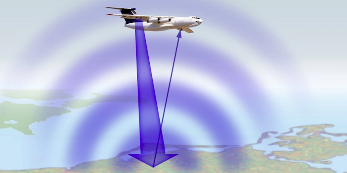
Basic principle of how altimeters record measurements. Image used courtesy of Radar Tutorial
Three main types of altimeters are commonly used today:
- Pressure altimeters operate according to atmospheric conditions.
- Radio and radar altimeters operate using electromagnetic waves.
- Optical altimeters operate using light waves and laser systems.
Operational Mechanisms
The largest portion of altimeters are barometric (mechanical). These units are driven by an internal spring (or capsule) within a sealed metal chamber that compresses in response to air pressure changes. That compression moves the gauge’s needle—giving altitude readouts in meters or feet.
Expansion within the chamber ultimately powers this mechanism. However, these instruments are sensitive to air pressure changes as weather conditions change. Instances like these can skew measurements.
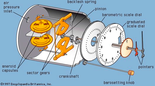
Diagram of a pressure altimeter. Image used courtesy of Encyclopædia Britannica
Modern barometric altimeters might also incorporate static pressure ports (or Pitot tubes) connected to lines. These lines transport air from the front of a moving object (like a plane) at a fixed rate. Velocity doesn’t impact this system, but air pressure changes are translated. When tubes are poorly designed, shock waves and errors can influence measurements.
That’s not to say that barometric altimeters cannot be electronic. Modern barometric units use a piezoresistive integrated circuit (IC). This IC deflects (or bends) proportionally to atmospheric pressure, thus changing the electrical resistance of the circuit. Because this resistance is monitored in real-time, the system can measure altitude based on assumptions. Signal processors are built into this IC as are voltage regulation circuits.
Piezoresistive IC-based barometric altimeter. Image used courtesy of Halit Eren
A constraint wafer maintains internal pressure from the backside of the circuit—whilst shielding any underlying sensor(s) from stressors accumulating within. Such setups are common within differential-pressure instruments.
Radio Altimeters
What if we require systems less susceptible to changing weather? Radio (or radar) altimeters harness radio-frequency (RF) signals to determine dynamic altitude. These models consist of a receiver-transmitter that works alongside separate antennas. Signals are beamed down to transmitters, to the ground, and then reflected back to the sender. A distance-time calculation is used to report altitude.
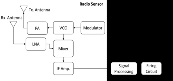
Block diagram of a basic radio altimeter. Image used courtesy of Fathy Ahmed
Radio altimeters utilize a fixed FM signal in a certain Hz range. While that frequency theoretically shouldn’t change from transmission to receipt, the FM frequency does tend to increase during its return trip. This logic is programmed into the onboard system, thus boosting the accuracy of the readout. Radio altimeters are often standalone units, yet may also show altitude in conjunction with electronic flight displays. Computers are crucial to such setups.
These instruments draw their power from the power supplies of other electronic systems. This typically happens at ignition or activation. As such, radar altimeters run via a circuit breaker—which either arms automatically or in response to onboard events. Electricity is then used to power embedded RF chips and antennas.
Optical Altimeters
Optical systems share many similarities with other energy-based technologies like LiDAR. Pulses of energy—often in the form of laser light waves—are transmitted and reflected back by nearby objects, including the ground. These “sight-based” systems are highly accurate while providing a dynamic topography of the surrounding world.
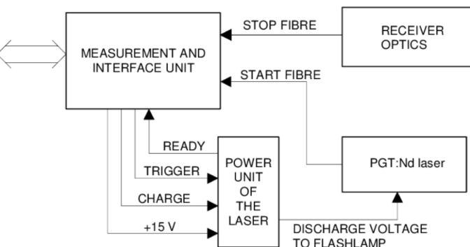
Block diagram of a laser altimeter. Image used courtesy of Veli Heikkinen
One might even say that optical altimeters operate similarly to echolocation, instead trading sound waves for light waves during calculation.
An emitter is required to direct light pulses toward the ground. Sensors receive any returned signals. Additionally, these optical units are paired with GPS receivers and inertial navigation systems (INS) to determine altitude—in relation to location—more precisely. Optical (or laser) variants are powered via the objects they’re mounted to or embedded within.
Altimeters will Drive Future Discoveries
It’s clear that today’s altimeters have come a long way from their purely-mechanical forerunners. Advancements in circuitry have paved the way for new altimeter designs. In response, engineers and scientists are harnessing these devices to pursue new discoveries. They’re also promising to make our existing systems safer than ever before.

